In case you don't know where to find a cut of the song by Nat King Cole, it's at
http://www.bing.com/videos/search?q=Get+your+kicks+on+route+66&FORM=VIRE1#view=detail&mid=CBB7505B33C262F8ACF6CBB7505B33C262F8ACF6
I left Lake Havasu City about 11:00 Monday morning 10/14 and headed north on AZ 95. I think the Arizonans believe that is the correct route for U.S. 95 to have take as it runs parallel on to the U.S. route on the other side of the Colorado River. It's hard to believe that a few days ago I was at the Mexican border and now I'm already 200 miles north of there. And it's already started getting cold. Of course I've gained elevation, too. Lake Havasu City is about 650 feet in elevation and Kingman AZ, my next stop is 3300 feet. I camped at Blake Ranch RV Park about 15 miles east of Kingman. The first thing I realized was that all the traffic was headed the other way.
The second was that I needed heat. I turned on my furnace and couldn't figure out why the dang thing tried to blow cold air all night. In the morning when I tried to light the stove for coffee, I realized that my propane gas tank was empty. No problem. I just switched tanks and suddenly I had both a stove and heat!
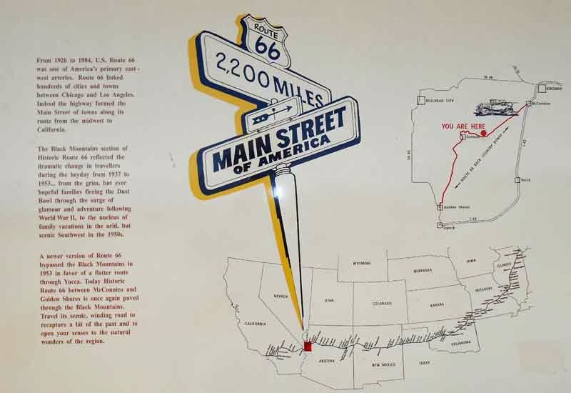
Since Kingman calls itself the heart of Route 66, I spent a good bit of time exploring the history and the route.
As soon as I saw this 1950 Studebaker Champion in the Route 66 Museum, I knew I had to do some travel on this road, even though I had said I wasn't interested in it. This car was parked in my yard for years in Mishawaka, IN. Well, I think ours was a 51 and gray, but we had a Champion that Dad probably screwed bolts onto somewhere. So, I decided to stay an extra day and see a bit of Route 66. The big draw was to go West over Sitgreaves Pass to Oatman like the folks in
Grapes of Wrath. Fortunately, my truck was in better shape than most of those escaping the dust bowl for the Land of Milk and Honey.
In Kingman, it's called Andy Devine Boulevard. I had a great time remembering the actor who was Cookie in the Roy Rogers Show, driving around in a Jeep while everyone else was on horseback. Also as the sheriff in The Man Who Shot Liberty Valance. That distinctive voice was readily recognized as Friar Tuck in the Robin Hood cartoon show, as well. Anyway. Heading West from Kingman, you dip down into the desert again and then have to climb.
Route 66 was called the Main Street of America, running from Chicago to Los Angeles. But, of course it was decommissioned in 1985 and replaced by the Interstate highways. In California and Arizona, most of it was taken over by Interstate 40, but there are some segments of the highway that still connect the small towns that still call it Main Street.
Getting over the pass is a narrow and treacherous segment that has an absolute vehicle length limit of 40 feet. Even my truck and little trailer are more than that. Many people had guides lead them during the 30s, or even paid local farmers to tow them over the Sitgreaves pass.
Even then, what they saw next had to be a little disheartening. This road really twists and turns until it ends up back in the Mohave Desert, where a lot of the migration ended as well.
The only town to speak of along this stretch is Oatman that has made a name for itself with gunfight reenactments and 'wild' burros in the street. Believe me, this fellow was about the tamest, best fed, and well-brushed wild burro you are ever likely to meet. He just stood in the middle of the street and waited for people to feed him and take his picture.
Route 66 is closed between Oatman and Needles due to a washout, so I continued West to Bullhead City, then--just because I'd never been there before--I continued across the river to Laughlin, NV. I played for a while in the casino and then headed back to my camp in Kingman (with a working furnace). I took a northerly route back rather than return over the pass.
On Wednesday, I continued to follow Route 66 East to Williams AZ. Going through Hackberry, I came to the "General Store" and saw the old gas pumps, still set to the price gas used to be. I don't remember gas at 15.9 cents per gallon, but I do remember it at 19.9 cents per gallon. All the towns along the way have shops and cafes that display relics of the heyday for Route 66, including a number of Corvettes.
I had lunch at the Roadkill Café in Seligman AZ, recommended to me by the host at Blake Ranch. Why doesn't anyone else serve a patty melt on rye bread??? About 17 miles later I had to join I-40 for a while, but I got off at Ash Fork when I saw a sign for the historic loop. What a surprise.
This is what most of U.S. Hwy 66 looks like now. The stretch from Needles to Seligman is the longest continuous stretch left. Just outside Ash Fork, the old highway hasn't been maintained in years and I was told that I could drive out on it in an ATV, but that a little ways out of town it just disappears in the meadow altogether, recaptured by nature.
Well, that got me to Williams AZ where I am on a hunt for my last surviving Uncle. So far no luck, but that's a story for tomorrow. And tomorrow, I'm headed up to the Grand Canyon for a visit. I'm looking forward to that.


No comments:
Post a Comment